


Geo7X Webinar Questions & Answers
NEI hosted a webinar this past summer pertaining to the new Trimble Geo7X. The webinar was a very detailed overview of the Geo7X. Several great questions were asked during the Geo7X Webinar, so we have detailed these Questions & Answers below:
Q. What antennas are compatible with the Geo7X?
A. Trimble has a few antennas that can be used with the Geo7X.
- Tempest – The Trimble® Tempest™ antenna is a high quality L1 GNSS antenna suitable for the submeter model of the Trimble Geo7X.
- Tornado – Dual frequency (L1/L2) GNSS antenna suitable for decimeter applications with the H-star model of the Trimble Geo7X
- Zephyr Model 2 – Dual frequency (L1/L2) GNSS antenna for decimeter to centimeter accuracy suitable for the H-star or Centimeter model of the Trimble Geo7X
Q. What are the upgrade options for the Geo 7X?
A. One of the unique advantages offered by the Geo 7 series is that all accuracy modes/configurations can be met with a single hardware variant.
Having a single model means that you can purchase the base Geo7X configuration with L1-capable GNSS receiver (which can achieve submeter-level accuracy), and the GNSS capability can be upgraded to H-Star performance enabling L1/L2 tracking (at decimeter-level accuracy), then subsequently upgraded to Centimeter performance (at centimeter-level accuracy).
Q: Do you have a video or write-up that shows steps to backup unit?
- Currently, we do not have a video but we will put this topic on are list. We recommend the following steps to back up your data.
- Connect the GeoExplorer, or other mobile device, to your computer via USB cable.
- Run MicroSoft ActiveSync (XP users) or Windows Mobile Device Center (WMDC).
- From there you can go into explore the device, browse the My Documents folder and grab the data files you need.
- TerraSync users can copy the TerraSync folder.
- Esri ArcPad users can copy the My ArcPad, Quick project(s), and other project folders.
- Esri ArcGIS Mobile users can copy the ArcGIS Mobile folder.
- Once you have copied the necessary files, you can then paste them somewhere on your computer. All other software and applications will have to be reloaded manually.
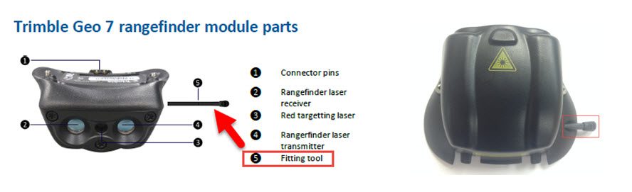
Q. Where is the tool to put on the rangefinder module?
A. The fitting tool can be hard to spot on the module. See the pictures below for the location.
Q. What is the fast calibration? What is recommended?
A. There are two calibration processes Full calibration and Fast calibration.
- Full calibration should be used when using the handheld for the first time, or after a significant change in environment (the handheld will tell you when full calibration is recommended).
o Full Sensor Calibration Video
- Fast calibration should be used at other times (e.g. when using the handheld in a new city or country, after changing the battery, or any other time that the device is reporting that it needs to be recalibrated.
o Rotate the handheld in all axes until the progress bar is full and the calibration is successful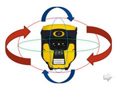
For instructions, best practices, and a video describing the sensor field calibration processes, refer to the support downloads area for the Geo 7X handheld on mgispartners.trimble.com.
- Geo7X Handheld: Orientation Sensor Calibration
- Geo7X Handheld Rangefinder: Aligning the Camera and Rangefinder
- Geo7X Handheld: Rangerfinder – Magnetic Declination
Q: Is there any advantage to using True North vs Magnetic North?
A. When using the Geo7X RangeFinder with TerraSync, it doesn’t matter what North reference you set RangeFinder or TerraSync to. Same settings is OK, different settings is also OK, possibly a registry entry TerraSync knows what North Reference the RangeFinder application is using and it takes this into account.
When using the Geo7X RangeFinder with another application where True / Magnetic is selectable, you must do the same as you’d do with external LaserAce or TruPulse etc. If the application does not know about magnetic declinations, I expect you’d set RangeFinder to True – Again, do the same as you’d do with external LaserAce or TruPulse etc.
The Geo7X RangeFinder does not directly know about location, but when you run RangeFinder application after power-up, the RangeFinder asks the Geo 7x OS for the magnetic declination for the current location.
So here’s the only True / Magnetic “Gotchas” I know about: The Geo7X OS uses the last-known position for declination, and the RangeFinder app only asks for declination when you first run it after turning on the Geo 7X or after soft or hard reset (when you Measure then Use, RangeFinder app just minimizes.)
Gotcha 1: if you factory-reset your Geo 7X or get a brand-new unit, then run RangeFinder before you get a position using the GNSS receiver, the OS does not have a “last location” and it returns a declination of 0. So then Rangefinder asks you to do a sensor calibration (which you do), and a laser align (which you do) but the declination of 0 sticks around until you soft-reset the Geo 7X or kill RangeFinder via task manager and run it again. Here is a Support Note describing this piece.
Q. What is a range pole?
A. Range poles are used when one wants to connect an external antenna to the Geo7X. You would also want to attach a bracket/clamp setup to hold the Geo7X to the pole, and a bi-pod can also be added as well. See image below.
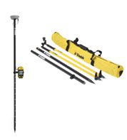
Monopoles are used when you don’t have an external antenna, but want to be more precise with your GNSS measurements or if will be using the integrated rangefinder.
Q. Do you recommend a monopole/range pole?
A. If you are looking for high precision or will be using the integrated rangefinder, then we recommend using a range pole with an external antenna, or a monopole if you won’t be using an external antenna. You will obtain better precisions since you can set the pole on or next to the target and level up, as well as being able to specify the vertical height of the GNSS antenna. The external antenna will help with better satellite receptions since it gets the GNSS antenna up over your head. Also, with the Geo7X attached to a pole, it will be easier to keep the laser steady and it helps with laser accuracy since you can measure the height and keep the antenna phase center close to the laser.
For more information, please read the Geo7X Handheld: Using the Carbon Fiber Monopole Kit support note.
Q. What is SBAS+?
A. SBAS+ is an enhancement to regular SBAS operation. The goal of SBAS+ is to use as much SBAS correction information as possible and as many satellites as possible to help improve yield and accuracy when positioning in SBAS mode on Floodlight™-enabled Geo 7X handhelds. SBAS+ enables the following:
• Uses autonomous (de-weighted) satellites in an SBAS+ position. Non-GPS, uncorrected satellites are used and contribute to the position solution. The autonomous satellites are de-weighted appropriately so that they add to the quality of the position without reducing the accuracy. As more satellites drop out of the position solution (for example in tougher GNSS conditions), the autonomous satellites have relatively more impact on the position.
• Use the SBAS ionospheric model whenever possible, even for satellites without an SBAS pseudorange correction term. One component of normal SBAS corrections is a regional model of ionospheric conditions. By modeling the ionosphere this impact of this error source can be mitigated. With SBAS+ the ionosphere model is also applied to non-SBAS corrected satellites (i.e. Galileo, BeiDou & GLONASS).
• Use SBAS corrected satellites in an autonomous position. If we don’t have at least 4 SBAS-corrected satellites, (or something else prevents us from a full SBAS+ position), the position solution will be autonomous. However, we can still use the individually corrected satellites in the autonomous position—increasing the quality of autonomous position results.
Check out this support note for more information on how the Geo7X handles SBAS.
Q. What is the proper way to charge my Geo7X battery?
A. Please refer to the Trimble Geo7X Handheld: Getting the most out of your batteries support note.
Helpful links
Geo7X Webinar Overview Webinar
- Username: Customer
- Password: MGIScustomer
- Browse to the webinar folder you wish to download
- Documentation
- Support Notes
- Downloads
Please contact nei support (1-800-949-1446) or submit a question for more information.